South Africa undertakes strategic environmental assessment for aquaculture development
Geographic Information Systems and stakeholder participation to identify suitable aquaculture areas
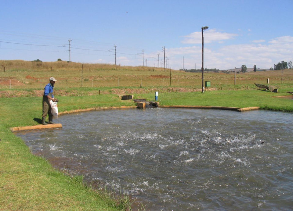
The aquaculture sector in South Africa is relatively small and has not been extensively developed. However, the South African Government has identified this sector as a development priority for its potential to create economic, job creation and food security opportunities.
South African aquaculture development faces many challenges ranging from climate change and access to land- and sea space, to the fact that it is a highly regulated sector with permits and authorizations required from a number of different departments at the national, provincial and local level. Streamlining and integration of the current environmental authorization framework can help address these challenges and allow the industry to reach its potential in an environmentally responsible manner.
To this end, the South African Department of Environmental Affairs and the Department of Agriculture, Forestry and Fisheries have commissioned the Council for Scientific and Industrial Research (CSIR) to conduct a Strategic Environmental Assessment (SEA) for aquaculture development.
The overarching goal of the SEA is to facilitate responsible and sustainable aquaculture within geographic areas that have been pre-assessed in terms of potential environmental (biophysical, social, economic) risks and opportunities. The SEA is an 18-month project, which is to be completed by the end of the first quarter 2018.
Identifying strategic areas for aquaculture
A key objective of the SEA process constituted a screening phase (completed in June 2017) which served to identify strategic aquaculture areas for marine- and freshwater aquaculture. The identification and investigation of strategic aquaculture areas aims to
- facilitate the development of aquaculture in an environmentally responsible manner;
- assist potential aquaculture developers by acting as a high-level development siting tool;
- maximize the sustainability of new aquaculture development; and
- stimulate the industry by reducing regulatory complexity and incentivizing development within the identified strategic aquaculture areas.
The identification of strategic aquaculture areas was an iterative process involving consultation with key stakeholders and a spatial analysis using multi-criteria Geographic Information Systems (GIS) analysis (Fig.1). Stakeholders that were consulted during the process included relevant national and provincial decision-makers and authorities, industry associations, conservation agencies, and research institutions.
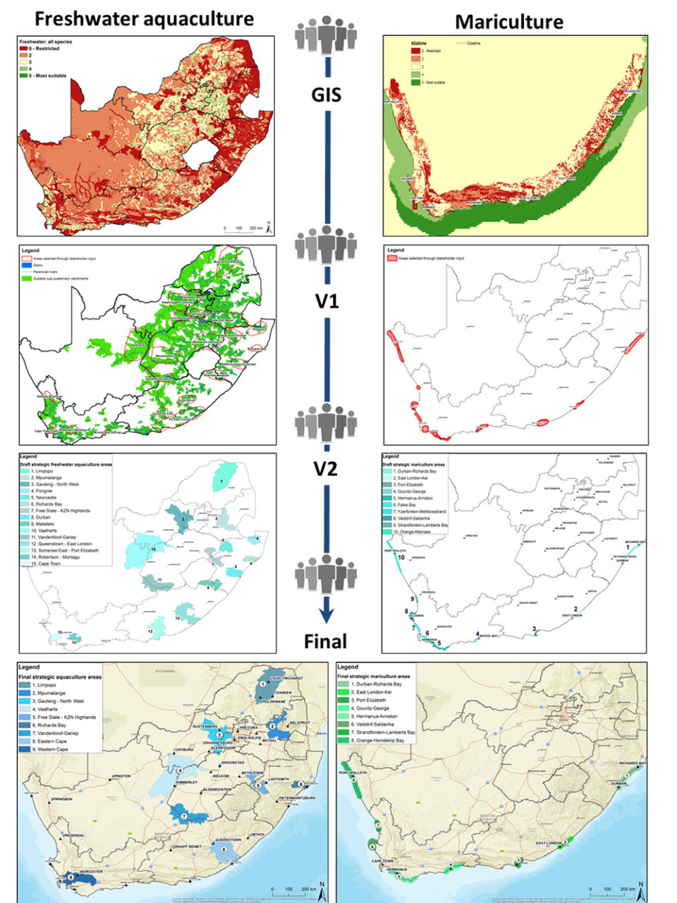
The screening phase was conducted in three main stages: 1) variable and threshold identification; 2) a multi-criteria analysis using Geographic Information Systems; and 3) area selection and refinement.
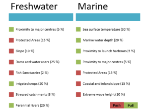
First, spatially explicit key siting variables, which would act as the input for the GIS analysis, were identified, selected and ranked in terms of importance in a workshop setting with stakeholders. The variables constituted push-and-pull factors which broadly represented environmental conditions and sensitivities; uses and users of the environment; as well as requirements of aquaculture facilities employing specific operational systems for breeding different species (Fig. 2).
The variables were used as input for a Weighted Overlay Analysis using GIS software which created a mosaic of spatial suitability classes ranging from least suitable/restricted to most suitable. The GIS analysis output was scrutinized by stakeholders, where participants were actively involved in delineating and refining broader areas from the most suitable classes. The inclusion or exclusion of areas was supported by rationales for doing so.
Results
A total of nine freshwater areas and eight marine areas were identified from this process, representing all nine South African provinces. The identified strategic aquaculture areas will serve as study areas for specialist investigation during the assessment phase of the SEA. Experts in their respective fields will undertake scientific assessments to highlight any potential environmental sensitivities where potential impacts associated with aquaculture development would not be appropriate, and make recommendation on best practice mitigation, management and monitoring requirements for responsible aquaculture.
Topics that will be investigated include biodiversity and ecology; heritage resources; visual and aesthetic resources; and socioeconomics. The specialist findings will serve as the evidentiary basis for a Decision Support Framework (DSF) that aims to provide guidance on site- and activity specific assessment processes and supply government with the necessary tools it needs to enable responsible, integrated and streamlined decision-making on aquaculture development. This includes guidance on regulations, decision-making and assessment protocols, and monitoring requirements.
Other outputs of the SEA include creating a database of all existing aquaculture facilities in South Africa; reviewing and updating biodiversity risk and benefit assessments for alien invasive species proposed for aquaculture (an assessment required in terms of the South African National Environmental Management Biodiversity Act); and mapping the presence of Nile tilapia in South African watercourses though a citizen science survey.
For more information on the SEA, and to access the detailed report on the Screening Phase, please visit the project website.
Authors
-

Environmental Scientist,
Council for Scientific and Industrial Research (CSIR)
Stellenbosch, South Africa -
Council for Scientific and Industrial Research (CSIR)
Stellenbosch, South Africa -
Council for Scientific and Industrial Research (CSIR)
Stellenbosch, South Africa
Related Posts
Health & Welfare
Acclimating shrimp postlarvae before pond stocking
Shrimp postlarvae acclimation before stocking into the various growout systems (ponds, raceways, tanks) is a critical – and often overlooked, sometimes taken for granted – step in the shrimp culture process. Various water quality parameters should be changed slowly so that the young shrimp have the time to gradually adapt to the new conditions.
Responsibility
Aquaculture Exchange: Peter Bridson
Peter Bridson, who steered aquaculture research for Seafood Watch and its highly influential marketplace recommendations for six years, now runs his own consultancy, Seagreen Research. He discusses global food security, certification standards and gradually changing perceptions about farmed salmon.
Responsibility
How will climate change impact seafood production?
Much work is needed to properly address and prepare for the potential impacts of climate change, and to continue increasing the contribution of seafood production to feed a growing human population.
Responsibility
Images: Small-scale aquaculture emerging in Africa
A study by University of Southampton Ph.D. candidate Alison Sky Simmance aims to investigate the role of small scale aquaculture in Malawi, a country where the demand for farmed fish is becoming more urgent in light of declining capture fisheries and high dependency on fish a vital source of animal protein.