Scientists tap supercomputer to understand the impact of climate change on fisheries
Climate modelers add ocean biogeochemistry and fisheries to forecasts of future upwelling using TACC’s Frontera supercomputer
A new project led by researchers at Texas A&M University is seeking to understand how changes to the climate and oceans will impact fisheries in the U.S. and around the world.
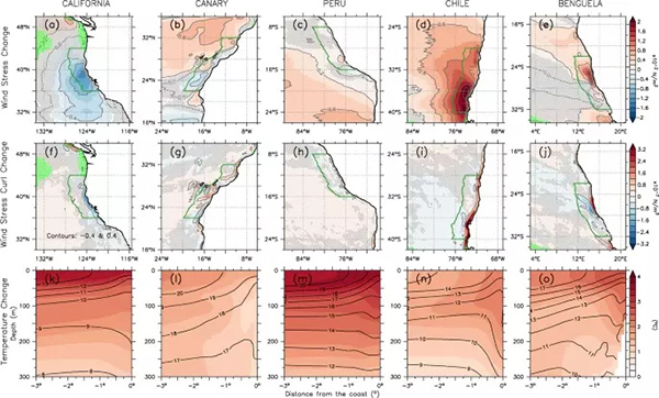
A handful of hyper-productive fisheries provide sustenance to a billion people and employ tens of millions. These fisheries occur on the eastern edges of the world’s oceans – off the West Coast of the U.S., the Canary Islands, Peru, Chile and Benguela. There, a process called upwelling brings cold water and nutrients to the surface, which in turn supports large numbers of larger sea creatures that humans depend on for sustenance.
“We’re interested in how climate change is going to alter upwelling and how the sustainability of the future fisheries will be impacted,” said Ping Chang, Louis and Elizabeth Scherck Chair in Oceanography at Texas A&M University (TAMU). “It turns out that when we increase the resolution of our climate models, we find that the upwelling simulation becomes much closer to reality.”
Funded by the National Science Foundation (NSF), the project aims to develop medium to long-term fishery forecasts, driven by some of the highest-resolution coupled climate forecasts ever run. It is one of the 16 Convergence Accelerator Phase 1 projects that address the “Blue Economy” – the sustainable use of ocean resources for economic growth. Convergence projects integrate scholars from different science disciplines.
![Ad for [Aquademia]](https://www.globalseafood.org/wp-content/uploads/2025/07/aquademia_web2025_1050x125.gif)
In the 1990s, marine biologist Andrew Bakun proposed that a warming climate would increase upwelling in the eastern boundary regions. He reasoned that since land is warming faster than the oceans, the temperature gradient between land and ocean would drive a stronger wind, which makes upwelling stronger. However, recent historical data suggests the opposite might in fact be the norm.
“A lot of papers written in the past use coarse resolution models that don’t resolve upwelling very well,” Chang said. “High-resolution models so far predict upwelling in most areas, not increasing. The models are predicting warmer, not colder temperatures in these waters. In Chile and Peru, the warming is quite significant – 2-3ºC warming in the worst-case scenario, which is business as usual. That can be bad news for upwelling.”
The areas where upwelling occurs are quite narrow and localized, but their impact on the marine ecosystem is very large. The eastern Pacific upwelling, for instance, is only about 100 kilometers (62 miles) wide. The climate models used by the Intergovernmental Panel on Climate Change (IPCC) have a resolution of 100 kilometers (62 miles) – and would therefore only produce one data point for the upwelling region, not nearly enough to predict future changes accurately.
On the other hand, the model used by Chang and his colleagues uses a resolution of 10 kilometers (6 miles) in each direction. These are 100 times more resolved than the IPCC models – and require roughly 100 times the computing power. The team uses the Frontera supercomputer at the Texas Advanced Computing Center (TACC) – the fastest academic supercomputer in the U.S. – to power their research.
Chang’s study relies on two separate but related sets of simulations. The first set involves an ensemble (the same model run with a slightly different starting point to produce a statistically valid result) of high-resolution coupled Earth system models. The second incorporates observed data in the atmosphere to generate realistic ocean states that are then used to initialize the model prediction. Starting from 1982, it will perform five-year retrospective forecasts to determine the skill of the model in forecasting upwelling effects.
“There’s a limit to how far out you can make a forecast,” Chang said. “Beyond a certain time limit, the model no longer has skill. At five years, our model still shows useful skill.”
The TAMU-NCAR project will be one of the first to incorporate biogeochemical models of the ocean and fisheries models into Earth system models at 10-kilometer (6-mile) resolution.
“Our goal is not routine forecasts,” said Chang. “What we want is a better understanding of the Earth system dynamics that are missing in current climate models to make our model and our methods better.”
The team reported their results in Nature’s Communications Earth & Environment in January 2023.
Follow the Advocate on Twitter @GSA_Advocate
Now that you've reached the end of the article ...
… please consider supporting GSA’s mission to advance responsible seafood practices through education, advocacy and third-party assurances. The Advocate aims to document the evolution of responsible seafood practices and share the expansive knowledge of our vast network of contributors.
By becoming a Global Seafood Alliance member, you’re ensuring that all of the pre-competitive work we do through member benefits, resources and events can continue. Individual membership costs just $50 a year.
Not a GSA member? Join us.
Author
Related Posts

Responsibility
Hottest ocean temperature record set in 2022 for seventh consecutive year
Research says a record-high ocean temperature combined with greater salinity could create inhospitable ocean conditions for marine life.

Fisheries
New study outlines recommendations for improving climate change resilience in U.S. fisheries
A new study has outlined recommendations for helping U.S. fisheries and fishing communities adapt to the effects of climate change.

Responsibility
Ocean ‘dead zones’ are growing, with human activity exacerbating the problem
Oxygen-deficient “dead zones” in the Pacific Ocean are expanding partly because of climate change and coastal nutrient discharge.
Intelligence
Can machine learning using climatic pattern data help predict harmful algal blooms earlier?
Study shows that a novel machine-learning approach using global climatic patterns can improve seasonal prediction of harmful algal blooms.