Fishing effort dynamics around the Galápagos Marine Reserve as described by Automatic Identification System data
Study shows the predominance of tuna purse seiners and drifting longliners, and the importance of adjusting fishing permits with nations and reinforcing law enforcement strategies
Many Exclusive Economic Zones (EEZs) of coastal nations are still vulnerable to illegal, unreported and unregulated (IUU) fishing due to the lack of resources for monitoring and controlling their waters. Unsustainable fishing threatens the management of fishery resources, food security, and people’s livelihoods around the world and is estimated to generate losses to countries’ tax revenues of up to U.S. $4 billion annually.
Remote vessel monitoring presents an opportunity to promote a new era of transparent marine governance and research. The Automatic Identification System (AIS) is a system originally designed to prevent ship collisions, but due to the open access and continuous transmission of information of the identity, current position, speed and direction of a vessel, amongst other data, AIS data can also be used to obtain information on the activity and behavior of fishing vessels at a relatively low cost.
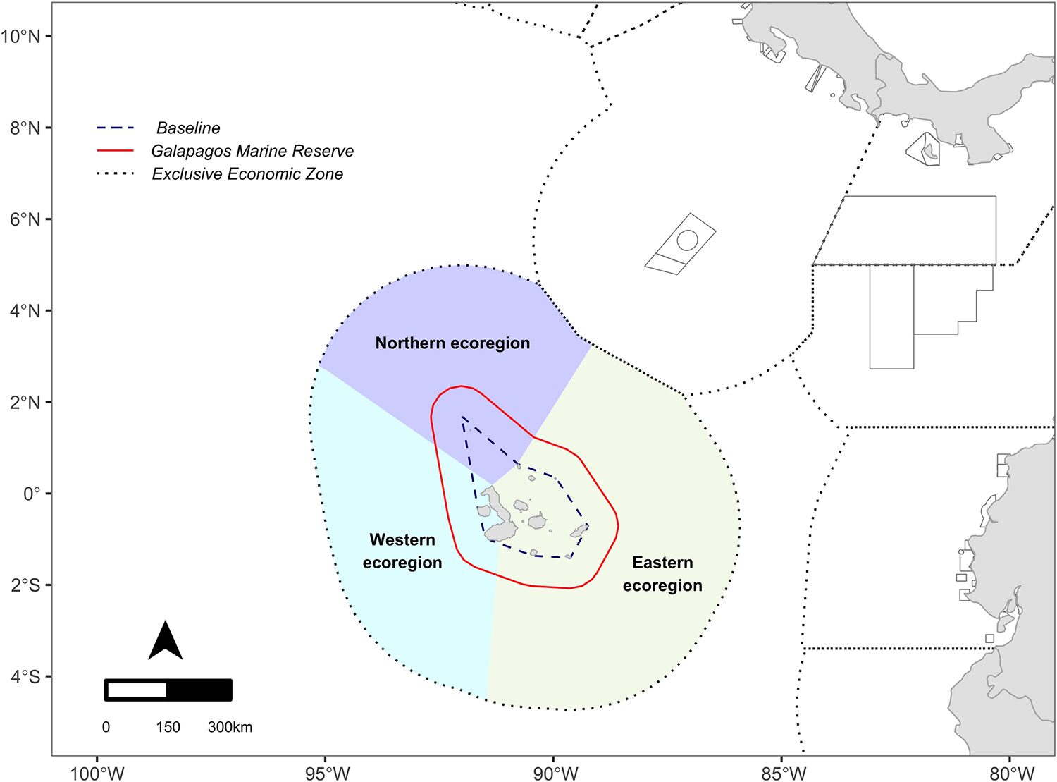
The Galápagos Marine Reserve (GMR) is a Marine Protected Area (MPA) of approximately 138,000 square km around the Galápagos Islands created in 1998 by the Government of Ecuador. It is a key area for the conservation of numerous threatened marine species. Since its creation, industrial fishing with any type of hydraulic, mechanized and technical fishing gear within the MPA has been prohibited. The creation of the GMR led to an increase in fishing productivity, but also to a change in the behavior of vessels that increased their fishing effort around the borders of the marine reserve.
The GMR is surrounded by a maritime area of Ecuadorian jurisdiction that extends 200 nautical miles from the Galápagos Islands baseline, the Ecuadorian Insular Exclusive Economic Zone (IEEZ). Important activities such as industrial fishing and tourism, key components of the Ecuadorian economy, are actively developed in this area.
![Ad for [BSP]](https://www.globalseafood.org/wp-content/uploads/2025/07/BSP_B2B_2025_1050x125.jpg)
Since 2012, non-governmental organizations have been generating high-resolution vessel activity data using AIS to promote transparent and sustainable fisheries. The potential of this tool to advise GMR managers and authorities has been previously assessed to characterize fishing effort around IEEZ and the interactions of the tuna purse-seine fishing fleets with the GMR. This type of information can be particularly useful for institutions or stakeholders in charge of management and law enforcement that do not have access to it or do not have the necessary tools to process it.
This article – summarized from the original publication (Chinacalle-Martínez, N. et al. 2024. Fishing effort dynamics around the Galápagos Marine Reserve as depicted by AIS data. PLoS ONE 19(4): e0282374) – presents the results of a detailed evaluation of the spatial as well as seasonal patterns of fishing activity by different flag states in the IEEZ and GMR.
This study used AIS data provided by Global Fishing Watch to assess the spatial distribution and seasonal dynamics of fishing effort by vessel flag within the GMR and the IEEZ from 2012 to 2021. For detailed information on the methodology and data used in this research, refer to the original publication.
Spatial distribution of fishing effort
Understanding the spatial distribution of fishing effort in a nation’s EEZ is useful for policy reformulation, particularly regarding access agreements that allow foreign fishing in national waters. This study provides detailed information on the main areas and fishing gears used by foreign and national fleets, which can contribute to improved spatial management of fisheries in the IEEZ and the GMR, particularly the less reported fisheries.
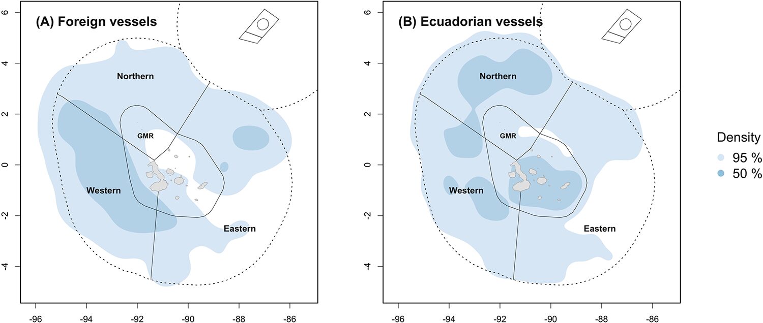
The waters around the MPA were mostly targeted by tuna purse seiners and drifting longlines, but purse seiners fished much further inside the IEEZ than longliners. The Ecuadorian fleet concentrated its fishing effort mainly in the northern ecoregion of the IEEZ and within the GMR, the latter likely due to the fishing activities of local Galápagos artisanal boats. Foreign fleets fished mostly near the GMR’s western boundary during the warm season, with a subtle shift observed towards its opposite boundary in the eastern ecoregion during the cold season.
Fishing effort by ecoregion
The eastern ecoregion exhibited the highest amount of fishing hours, with vessels operating more evenly distributed within the IEEZ yet clustered within the GMR. Differently, the western and northern ecoregions exhibited constant clustering in two areas: purse-seines preferring the western ecoregion near the border next to Isabela and Fernandina Islands, and drifting longlines the northern ecoregion in the area north to Darwin Island.
The GMR lies in the confluence of several surface and underwater marine currents whose interactions boost the overall biological productivity around the islands, particularly in the west of the reserve where the upwelling of nutrient-rich cold waters occurs. These conditions create an area of relatively stable species-habitat relationship that favors the overall diversity of the area, which is taken advantage by foreign and Ecuadorean purse-seine fleets targeting tuna, billfish and swordfish.
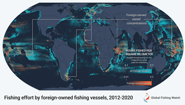
Putting IUU fishing on the map: Global Fishing Watch intends to bring the invisible into view
The northern ecoregion represents a unique “hotspot” for sharks, particularly over the seamounts found along the Cocos Ridge. While previous analysis of AIS data did not depict this ecoregion as of high fishing interest, various researchers denoted the area is an important fishing ground for the pelagic thresher shark and blue marlin. The high abundance of sharks over this region could be drawing the interest of the Ecuadoran and foreign drifting longline fleets during the cold season to fish on these species.
Overall, the observed fishing patterns around the GMR from AIS data appear to be tied to the seasonality of the oceanographic setting linked to the resource being targeted. This type of information can also be used to make predictions of fishing activities based on environmental data to facilitate monitoring and surveillance by enforcement authorities.
Fishing by foreign flags
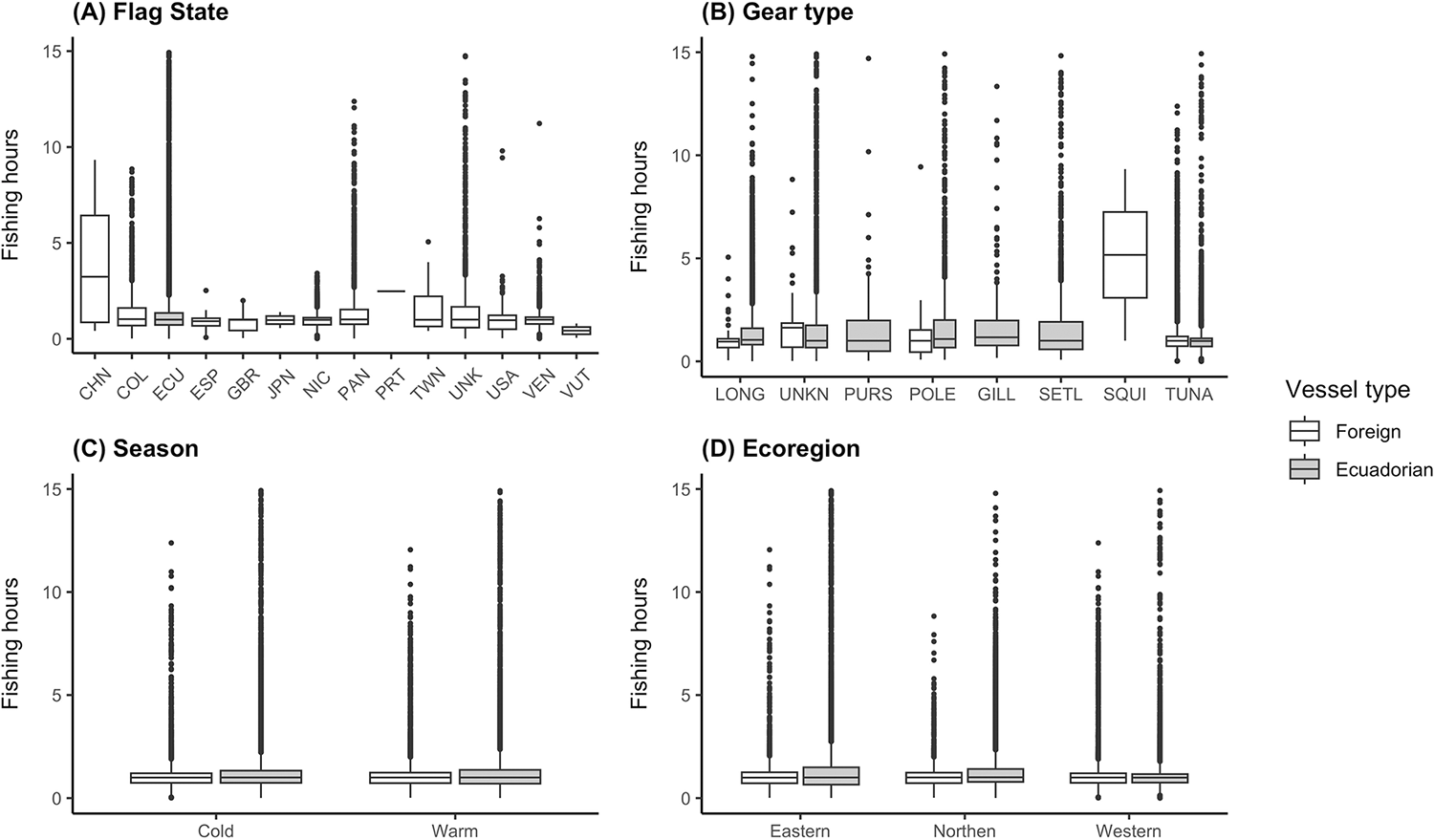
The observed fishing patterns by flag and gear type reported by our study align with previous work using AIS data that examined fishing activity in Ecuadorean waters, yet found Colombia as the leading foreign flag operating within the IEEZ. These differences may respond to the use of a bigger dataset processed with refined algorithms into our analysis, an increased number of fishing permits allocated to other countries (such as Panama), and, in the case of China, the steady increase in operations around Ecuador’s IEEZ since 2016.
Our study also found the IEEZ and the GMR were fished by 13 foreign flags, of which seven do not belong to the coastal states of the Eastern Tropical Pacific Ocean. During 2012–2018, AIS data revealed that the Eastern Tropical Pacific fishing effort was dominated mostly by Chinese and Taiwanese flag squid jiggers (64 percent), followed by tuna purse-seiners (17 percent) and drifting longlines (15 percent), both flagged to a wider range of countries.
Similar results have been reported in other EEZs, where distant-water fleets dominate fishing in these areas and often approach protected areas. The presence of distant-water fleets in the IEEZ may be due to Ecuador’s fishing agreements and permits with these countries. The United Nations Convention on the Law of the Sea (UNCLOS) gives nations exclusive rights to their open waters EEZ, meaning foreign vessels can operate within these under specific agreements through their State Departments.
Fishing effort within GMR
A different scenario is observed for foreign vessels fishing within the GMR. For this MPA, only local (to Galápagos) artisanal fishers are allowed to fish and under specific gear type and fishing power characteristics. Yet, since the creation of the GMR in 1998, there have been multiple of seizures of boats from Ecuador (mainland), Costa Rica, Colombia and Japan illegally operating within the marine reserve. Testimonies from Galápagos fishermen corroborate that unauthorized fishing by industrial vessels is recurrent within 40 nautical miles of this MPA.
Our study identified suspicious fishing activities from Colombia, Japan, Nicaragua, Panama, USA, Venezuela, Vanuatu, and ‘Unknown flags’ within the GMR. It is noteworthy that most of these records are in the southcentral region at an entry distance of nearly 100 km in the reserve. Out of these, Vanuatu and Japan are the only ones with a few fishing events registered close to port areas of the GMR, and not for the IEEZ. Since it is unlikely these vessels were fishing right in front of the main navy and park ranger offices, a potential misidentification by the algorithm could be the reason why those vessels were flagged as fishing.
A detailed analysis of the full AIS track data, coupled with declared entry details to port authorities, is highly recommended to detect common vessel behaviors that could lead to illegal fishing events within the reserve boundaries. This information could aid managers and authorities in developing tailored management and cost-effective surveillance plans for foreign and Ecuadorian industrial fishing boats entering the reserve under alleged health, mechanical or other emergencies.
Local artisanal fleet
The concentration of fishing activities within the GMR observed by ‘Unknown flags,’ or by Ecuadorean vessels using gears including other purse-seines, set gillnets, set longlines and unknown fishing gears, are attributable to the local (to Galápagos) artisanal vessels that are legally operating within the reserve. The spatial distribution of fishing effort of Galápagos artisanal boats is influenced by several geographical (e.g., latitude, longitude, homeport), oceanographic (e.g., El Niño-Southern Oscillation), social and economic (e.g., target species, vessel type, revenues) variables.
Limitations of AIS data
Our study demonstrated the value of AIS data to analyze spatial and seasonal patterns of global fisheries in and around an MPA. Nevertheless, since these data do not provide information on fishing hours and the fishing gear used in itself, machine learning algorithms calculate the probability that a vessel is fishing based on the type of gear and its movements. The identification of vessels and their fishing activities is limited by the fact that not all fishing vessels use this system, the ones that use it may present incorrect or incomplete identity data in the official vessel records, or because they choose to turn off the AIS to cover potentially illegal operations. Another important limitation is that the algorithm cannot currently properly identify vessels that use multiple fishing gears or differentiate between their fishing activities.
Perspectives
In this work, we analyzed AIS-based fishing effort data over space and time (seasons) to characterize patterns of fishing activity and key players by flag state in commercial fisheries. This data can provide a significant step forward in achieving sustainable fisheries management and improving offshore maritime planning because it provides data on less studied areas, gear types and flags in the IEEZ and GMR. However, this information and its interpretation should be used with caution due to the nature and limitations of the AIS data.
The identification of apparent fishing activities by 13 foreign fleets in the IEEZ and within GMR further supports the relevance of these waters for commercial fishing. Given this situation, it is important to adjust fishing permits with nations and reinforce law enforcement strategies in the southcentral region, where most of these suspicious fishing activities were recorded.
Our study also revealed the predominance of vessels fishing with tuna purse seines and drifting longlines in the northern and western ecoregions, probably because the oceanographic conditions create a highly productive area that favors the presence of species such as tuna, billfish, swordfish and sharks. Yet, we recommended to deepen the understanding of the fishing effort allocation in relation to the environmental data around the GMR.
Now that you've reached the end of the article ...
… please consider supporting GSA’s mission to advance responsible seafood practices through education, advocacy and third-party assurances. The Advocate aims to document the evolution of responsible seafood practices and share the expansive knowledge of our vast network of contributors.
By becoming a Global Seafood Alliance member, you’re ensuring that all of the pre-competitive work we do through member benefits, resources and events can continue. Individual membership costs just $50 a year.
Not a GSA member? Join us.
Author
-

Corresponding author
Pontificia Universidad Católica del Ecuador–Sede Manabí, Manabí, Ecuador
Related Posts

Fisheries
A review of bycatch in the Antarctic krill trawl fishery
Understanding the significance of bycatch is critical to managing Antarctic krill, a keystone species and the largest fishery in the Southern Ocean.
Innovation & Investment
‘We want change’: How a seafood database aims to influence seafood investment decisions
Planet Tracker’s seafood database evaluates seafood companies’ exposure to sustainability risks like overfishing and IUU fishing.
Intelligence
GDST recognizes first software products for interoperable digital traceability
The Global Dialogue on Seafood Traceability said three tech vendors and a platform have digital traceability products to implement GDST standards.
Fisheries
GPS data may identify potential IUU fishing behavior
A study led by Global Fishing Watch provides new insight into potential IUU fishing behavior that could help improve fisheries management.