A deep learning model for short- and medium-term predictions of spatiotemporal distribution of marine fishing effort
Study develops a deep learning model that can simultaneously interpret and integrate the spatio-temporal characteristics of fishing intensity and environmental factors
The absence of refined global marine capture information limits the oversight of high seas fisheries and hampers the implementation of ecological management policies. Moreover, inadequate conservation measures, weak environmental regulations, and overfishing remain serious challenges. These issues highlight the urgent need for detailed capture information to ensure the sustainable development of marine fisheries resources. Predicting the distribution of fishing effort can provide guidance for fisheries resource management, and marine resource management and planning also require refined predictions of future marine capture information.
Fishing effort is more challenging to predict than fishery resource conditions. Fishing operations are continuously dynamic spatiotemporal processes that often involve transfers between different grid areas. Fisheries producers make subsequent fishing decisions at sea based on experience and marine environmental conditions. The spatial distribution of fishing effort is a continuously dynamic process driven by both external factors (e.g., marine environmental conditions) and internal factors (e.g., previous and surrounding fishing activities).
As a result, fishing effort prediction is essentially a spatiotemporal forecasting problem, requiring models that capture both spatial and temporal dependencies to address complex dynamic changes. However, these dimensionality reduction approaches fail to reflect the temporal trends and spatial correlations of fishing information.
Deep learning methods have been increasingly applied to show the relationships between local spatial characteristics of fishing grounds and environmental factors. But current research generally has two major limitations: first, most predictive models consider only the local effects of environmental variables while neglecting the continuous spatial dynamics of fishery data; and second, many studies adopt real-time prediction strategies, overlooking the temporal evolution of fishing grounds, thus constraining the models’ forecasting capability. Therefore, determining a reasonable spatiotemporal scale is critical for ensuring model accuracy.
![Ad for [Aquademia]](https://www.globalseafood.org/wp-content/uploads/2025/07/aquademia_web2025_1050x125.gif)
This article – summarized from the original publication (Yang, S. et al. 2025. Short- and Medium-Term Predictions of Spatiotemporal Distribution of Marine Fishing Efforts Using Deep Learning. Fishes 2025, 10(10), 479) – presents the results of a study that proposed a deep learning model that can simultaneously interpret and integrate the spatiotemporal characteristics of fishing intensity and environmental factors, providing a precise, high-dimensional predictive pathway.
Study area and databases
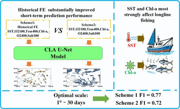
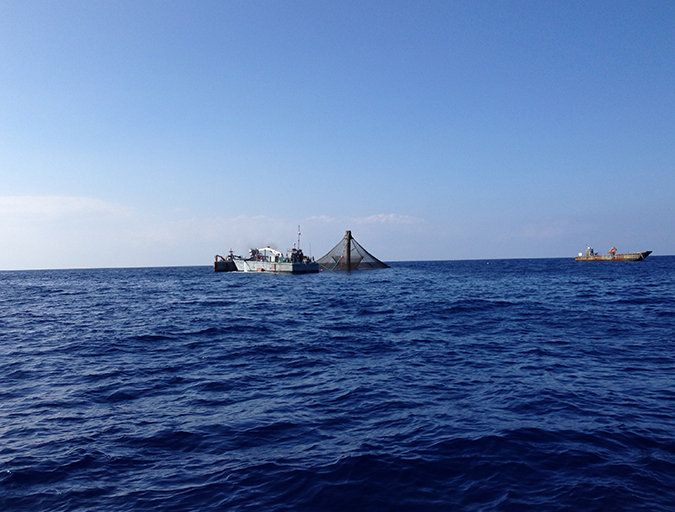
This study focused on the tuna longline fishery in the Western and Central Pacific Ocean (WCPO). It used a constructed a CLA U-Net deep learning model – a type of artificial intelligence model used for processing images, particularly in tasks like identifying or segmenting specific parts of an image (e.g., separating objects or regions). The model was used to predict fishing effort (FE) distribution based on 2017–2023 FE records and environmental variables. Two modeling schemes were designed: Scheme 1 incorporated both historical FE and environmental data, while Scheme 2 used only environmental variables.
The fishing type and fishing effort data were sourced from the Global Fishing Watch (GFW). This website provides daily navigation trajectories and fishing operation times for global fishing vessels, including date, longitude, latitude, navigation time, fishing time, and other relevant data. Fishing effort was defined as the total fishing hours of vessels within each grid cell, derived from automatic detection system (AIS)-based detections provided by GFW. GFW classifies whether fishing vessels are engaged in fishing activities by analyzing high-resolution AIS trajectory data in combination with neural network models. Environmental data – including sea surface temperature, dissolved oxygen concentration at 100-meter and 400-meter depths, temperature at 400 meters, chlorophyll-a concentration, and salinity at 100 meters were used as the environmental factors for this study. Marine environmental data were downloaded from the Copernicus website.
For detailed information on the study area; deep learning model constructed; and data sources and analysis, refer to the original publication.
Spatiotemporal prediction of fishing effort
This study employed the CLA U-Net model to predict the short- and medium-term spatiotemporal distribution of tuna longline fishing intensity in the western and central Pacific. Compared with Crespo et al., Scheme 1 and Scheme 2 showed slightly lower accuracy, primarily due to differences in study design: Crespo et al. predicted fishing effort within the same month using contemporaneous environmental variables, whereas this study predicted future distributions from historical data, a more challenging task.
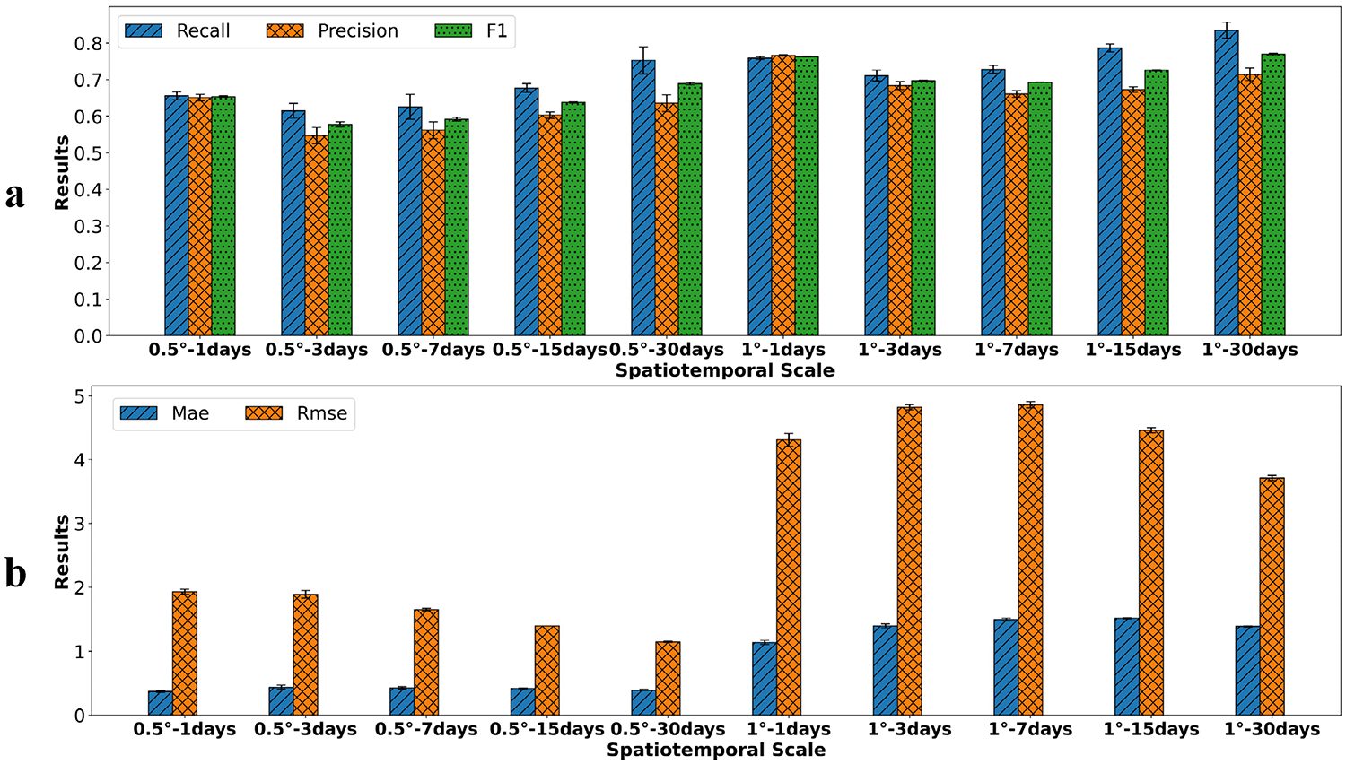
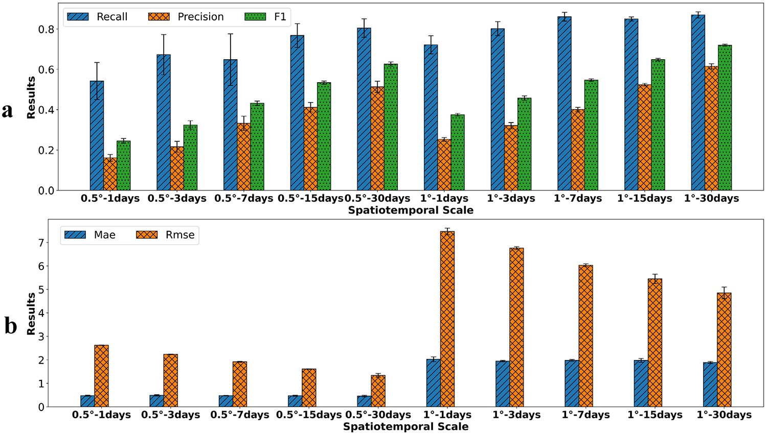
Study results indicate that study area, prediction targets, model design, and spatial resolution significantly affect performance, and comprehensive evaluation using multiple metrics is essential under different research frameworks. In Scheme 1, the CLA U-Net model achieved strong performance across all spatiotemporal scales. In Scheme 2, although the model performed sub-optimally at finer temporal resolutions, it demonstrated satisfactory results at coarser temporal scales. Overall, the CLA U-Net model effectively captures the dependencies in both temporal and spatial dimensions, demonstrating significant application potential in predicting marine fishing intensity.
Compared with traditional regression models and machine learning methods, this model extends the input and output dimensions from one dimension to multiple dimensions. The spatial distribution of fishing intensity is a continuous dynamic evolution process that is driven by the coupling of internal and external factors. When data conditions are sufficient, deep learning methods for spatiotemporal prediction should be prioritized for forecasting the spatial information of fisheries. Future research could enhance predictive accuracy and practical applicability by integrating longer time series, additional environmental variables, and a broader set of socioeconomic factors.
Impact of historical fishing information on model outcomes
Currently, studies incorporating historical fishing information as model input remain relatively limited. It is worth noting that, although studies directly incorporating historical fishing data for prediction remain limited in the fisheries field, similar approaches have been widely adopted in other domains; for instance, in short-term rainfall forecasting, researchers often combine historical radar echo data or meteorological observations with environmental variables as model inputs to improve prediction accuracy and stability. These cross-disciplinary studies demonstrate that leveraging historical dynamic information to predict future activities is an effective and reliable modeling strategy, thereby supporting the rationale of Scheme 1 in this study.
A comparative analysis of Scheme 1 and Scheme 2 indicates that the introduction of historical fishing information significantly enhances the model’s performance in predicting fishing locations and intensity. The habitat distribution of tuna is profoundly influenced by marine environmental factors. Areas where oceanic environmental conditions satisfy the habitat requirements of tuna may serve as potential fishing grounds. Neural networks trained solely on environmental predictors can learn the ecological niche of tuna longline operations and thus forecast likely operating areas. By integrating historical fishing intensity data across multiple time steps, the model can better capture vessel movement patterns, thereby improving the accuracy of predictions for tuna longline fishing activities.
Variability analysis of model performance across different spatiotemporal scales
Numerous studies show that the choice of spatiotemporal scales is crucial for predicting fishery resource distributions. In this study, coarser spatial resolution (1 degree) improved accuracy in predicting fishing locations, while precision in predicting fishing intensity was lower due to spatial aggregation effects. Larger grid cells average data, reducing local fluctuations and noise, which enhances model performance in classification tasks. At finer resolutions, the fishing effort is typically lower, leading to better predictions of fishing intensity since smaller grid cells can retain detailed local environmental information.
At the same spatial scale, the best temporal scale for both Scheme 1 and Scheme 2 was found to be 30 days. Different trends occurred with increasing temporal scale: the accuracy of Scheme 1 first decreased and then increased, while Scheme 2 consistently improved. Scheme 2 had a severe imbalance between observed fishing locations and non-fishing locations at smaller temporal scales, affecting the neural network’s performance and causing over-prediction of fishing areas. Fishers often choose fishing spots based on specific environmental factors, making the conditions at fishing and non-fishing sites similar and complicating accurate predictions.
As the temporal scale increases, data aggregation helps reduce noise and clarify relationships between fishing activity and environmental conditions, improving model accuracy. The two schemes reacted differently to temporal scale changes because Scheme 1 included historical fishing data. The prediction accuracy varied as the temporal scale changed, with longer intervals allowing the model to capture general fishing trends. Overall, selecting the right spatiotemporal scales significantly affects model performance, and results may vary due to species and methods used. Also, it is critical to consider oceanic conditions and biological traits when choosing these scales.
Differences in study species and methodological approaches can lead to varying effects of spatiotemporal scale on model performance. Therefore, when selecting appropriate spatiotemporal scales, it is essential to consider both oceanic environmental conditions and the biological characteristics of the target species.
Analysis of variable importance in the model
The spatial distribution of fishing activities is a continuously dynamic process influenced by both external factors (e.g., marine environmental conditions) and internal factors (e.g., prior and surrounding fishing activities). The average importance of variables at different spatial and temporal scales in Scheme 1 indicates that the importance of historical catch data is markedly greater than that of environmental variables, whereas the differences in importance among the six environmental variables are relatively minor.
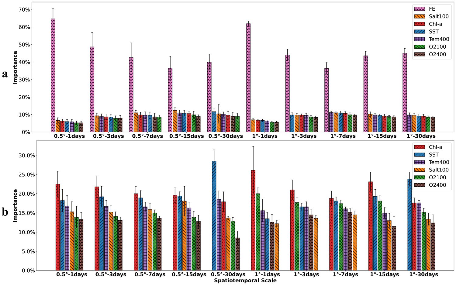
Several studies indicate a close link between marine environmental conditions and fishing grounds. Different environmental factors affect fishing distribution at various spatio-temporal scales. Sea surface temperature is recognized as a key factor for tuna longline fishing, and it is particularly influential at longer time scales. Chlorophyll-a also plays a significant role, as it relates to tuna food availability. Other factors, like salinity and dissolved oxygen levels, are important for tuna growth and distribution. The study confirms that these variables are critical in shaping fishing efforts, supporting better predictive models for fishing activity.
Perspectives
This study applied the CLA U-Net model to predict short- and medium-term spatiotemporal distributions of tuna longline fishing activities in the WCPO. Two modeling schemes were evaluated: Scheme 1, incorporating both historical fishing effort (FE) and environmental variables, and Scheme 2, using environmental variables only.
The results support the following conclusions: First, the CLA U-Net model effectively predicts the spatiotemporal distribution of fishing intensity for both short- and medium-term periods. Second, historical fishing intensity data substantially enhance prediction performance. Scheme 1, which includes these data, better captures spatiotemporal trends, while Scheme 2 identifies a broader set of potential fishing areas but with higher false-positive. Third, spatiotemporal scale significantly affects model performance. And fourth, variable importance analysis shows that historical FE data dominate predictions in Scheme 1, while sea surface temperature and chlorophyll-a are the most influential predictors in Scheme 2.
In summary, this study offers new avenues for predicting future spatial patterns of global fisheries activities and assessing the impacts of climate change. Future research could benefit from integrating longer time series, additional environmental variables, and socioeconomic drivers to further improve prediction accuracy and enhance the practical applicability of the model.
Now that you've reached the end of the article ...
… please consider supporting GSA’s mission to advance responsible seafood practices through education, advocacy and third-party assurances. The Advocate aims to document the evolution of responsible seafood practices and share the expansive knowledge of our vast network of contributors.
By becoming a Global Seafood Alliance member, you’re ensuring that all of the pre-competitive work we do through member benefits, resources and events can continue. Individual membership costs just $50 a year.
Not a GSA member? Join us.
Authors
-

Corresponding author
Key Laboratory of Fisheries Remote Sensing, Ministry of Agriculture and Rural Affairs, East China Sea Fisheries Research Institute, Chinese Academy of Fishery Sciences, Shanghai 200090, China
-
Key Laboratory of Fisheries Remote Sensing, Ministry of Agriculture and Rural Affairs, East China Sea Fisheries Research Institute, Chinese Academy of Fishery Sciences, Shanghai 200090, China
-
Key Laboratory of Fisheries Remote Sensing, Ministry of Agriculture and Rural Affairs, East China Sea Fisheries Research Institute, Chinese Academy of Fishery Sciences, Shanghai 200090, China
-
Key Laboratory of Fisheries Remote Sensing, Ministry of Agriculture and Rural Affairs, East China Sea Fisheries Research Institute, Chinese Academy of Fishery Sciences, Shanghai 200090, China
-
Key Laboratory of Fisheries Remote Sensing, Ministry of Agriculture and Rural Affairs, East China Sea Fisheries Research Institute, Chinese Academy of Fishery Sciences, Shanghai 200090, China
-
Key Laboratory of Fisheries Remote Sensing, Ministry of Agriculture and Rural Affairs, East China Sea Fisheries Research Institute, Chinese Academy of Fishery Sciences, Shanghai 200090, China
-
Key Laboratory of Fisheries Remote Sensing, Ministry of Agriculture and Rural Affairs, East China Sea Fisheries Research Institute, Chinese Academy of Fishery Sciences, Shanghai 200090, China
-
Key Laboratory of Fisheries Remote Sensing, Ministry of Agriculture and Rural Affairs, East China Sea Fisheries Research Institute, Chinese Academy of Fishery Sciences, Shanghai 200090, China
-
Key Laboratory of Fisheries Remote Sensing, Ministry of Agriculture and Rural Affairs, East China Sea Fisheries Research Institute, Chinese Academy of Fishery Sciences, Shanghai 200090, China
-
Key Laboratory of Fisheries Remote Sensing, Ministry of Agriculture and Rural Affairs, East China Sea Fisheries Research Institute, Chinese Academy of Fishery Sciences, Shanghai 200090, China
Related Posts
Intelligence
‘Spatiotemporal patterns’ indicate improving perceptions of aquaculture
A study led by University of California Santa Barbara researchers has found that public sentiment toward aquaculture improves over time, a potentially important development with growing interest in offshore aquaculture.
Fisheries
Decadal changes in nearshore habitats drive disconnect between settlement and fishery recruitment of western rock lobster in Australia
Monitoring marine habitats like submerged vegetation can complement long-term fishery data collection and coastal management.
Fisheries
Projecting the shift of chub mackerel spawning grounds from climate change in the Western North Pacific Ocean
Study results can help estimate and predict chub mackerel distributions during early life stages, subsequent exploitable abundance and fishery production.
Fisheries
Trawl surveys, environmental DNA analysis and scientific echo sounder techniques to analyze the East China Sea fisheries resources
The complementary strengths of each method of fisheries analysis support the understanding of spatiotemporal dynamics of fish communities.